About
Global Navigation Satellite Systems (GNSS) enable the measurement of surface deformations at various spatial and temporal scales, offering valuable information on the Earth’s geodynamic processes. In addition, the integration of GNSS with other geodetic and geophysical techniques strengthens the ability to monitor and interpret solid Earth dynamics, contributing to natural hazard assessment and long-term geophysical research.
Infrastructure and Collaborative Framework
The TCS GNSS Data and Products relies on a distributed GNSS infrastructure, composed of continuously tracking GNSS stations, data nodes, data analysis centers, and dedicate portals to access metadata, data, and derived products. They are operated and maintained by national mapping agencies, public institutions, and private organizations. These entities ensure the continuous acquisition and sharing of GNSS data (and associated metadata), as well as the computation and distribution of high-quality geodetic products such as position time series, velocity fields, and strain rate fields. A key partner in this effort is EUREF (Reference Frame Sub-Commission for Europe), which plays a fundamental role in guaranteeing data quality, standardization, and the adoption of best practices within the European geodetic community, reinforcing open science principles.
Applications and Societal Impact
GNSS enables precise measurement of crustal deformation across various temporal scales, from seconds (e.g., co-seismic displacements) to decades (e.g., plate motion). This continuous monitoring enhances our understanding of geodynamic processes, such as plate tectonic boundaries, regional strain accumulation, and vertical land motion. Beyond scientific research, GNSS plays a key role in geohazard assessment, helping to detect and monitor crustal deformation linked to seismic cycles, volcanic unrest, and slow-slip events. It also contributes to land deformation studies at local and regional scales, supporting analyses of long-term surface changes, including those related to sea-level variation. Additionally, GNSS data improves the realization and access to geodetic reference frames, necessary for geospatial applications and reliable long-term monitoring of Earth.
Tools and Platforms
To facilitate access and standardization, the EPOS’ GNSS infrastructure is supported by four dedicated pan-European portals for proving access to GNSS data, products, metadata, and quality checks. These portals provide centralized access to GNSS resources and ensure the integration of different datasets. The GLASS software has been developed to interconnect these portals, enhancing the management and dissemination of GNSS data and products across Europe.
Future Goals and Aspirations
The TCS GNSS aims to expand GNSS data coverage, integrating more stations to enhance the spatial and temporal (high-rate) resolution of geodetic observations. It also seeks to reduce latency of the GNSS products and develop new scientific products, improving the accuracy and usability of position time series, velocity fields, and strain rate fields. A key priority is to ensure that GNSS data and products are aligned with the FAIR data principles as this will optimize their use. Additionally, strengthening collaborations within the geoscience community and integrating GNSS with complementary techniques will further enhance the Earth system monitoring, supporting innovation and open science.
Data & Services
GNSS data comes from various national and regional GNSS networks. Many of them are part of the EUREF Permanent GNSS Network (EPN), sustained by EUREF, a European-level organisation that maintains a European Geodetic Reference Systems network. Other examples are the French RENAG (REseau NAtional GNSS permanent) and the Italian RING (Rete Integrata Nazionale GNSS) networks.
The Thematic Core Service GNSS Data and Products standardises and provides access to a variety of european and regional geodetic data, metadata, products, and software in support of Solid Earth Sciences. Activities and services are coordinated within the EPOS infrastructure to ensure interoperability with the GNSS gateways and EPOS' ICS data portal.
M3G
M3G stands for “Metadata Management and distribution system for Multiple GNSS Networks”. GNSS station managers use M3G to upload, validate, and distribute their GNSS station metadata such as IGS-style site logs, information about local networks, data owner, DOIs, data license, etc...
M3G's primary goal is to collect rich metadata as recommended by the FAIR data principles. M3G's metadata of EPOS-GNSS stations are provided to the EPOS-GNSS Data Gateway and are also available through M3G's APIs and web portal.
M3G is maintained by the Royal Observatory of Belgium as a common service of EUREF and EPOS.
GNSS Data Gateway Portal
The GNSS Data Gateway Portal is a virtual infrastructure to store and disseminate GNSS data and products from existing Research Infrastructures.
The portal stores EPOS stations metadata and enables access to the GNSS observations and products. GNSS data from all over Europe, including EUREF Permanent GNSS Network (EPN), is available in this portal. Users can select the stations of their interest and the corresponding set of metadata, such as station code, site name, longitude, latitude, elevation, and other information. Users can also select stations on the map, either by drawing a rectangle, a circle or a polygon around them, or providing bounding box coordinates.
GNSS Product Portal
Data from the GNSS Data Gateway Portal is validated and analysed in different GNSS analysis centres and made available in the GNSS Product Portal.
The portal enables access to the GNSS observations and derived products, such as daily and weekly time series, estimated velocities and strain rate maps from various regions in Europe. Graphical interfaces enable station visualisation and multiple queries over stations and associated metadata, allowing users to retrieve the desired information.
Data Quality Monitoring portal
The EPOS-GNSS data quality monitoring web portal is the public front-end of the “EPOS-GNSS Data Quality Monitoring Service” (DQMS) maintained by the Royal Observatory of Belgium. The DQMS monitors the availability and quality of the daily GNSS data that are made discoverable through the TCS “GNSS data and products”.
The information provided by the portal is used e.g., as feedback to GNSS data suppliers or as input to scientists interpreting the results of the GNSS data products. The DQMS portal provides maps and plots that are updated at least daily.
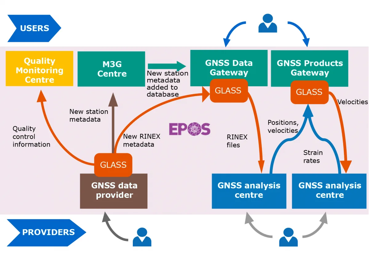
Data and products are provided to the TCS GNSS by six EPOS official analysis centres:
- LTK (Department of Geodesy, Remote Sensing and Land Offices – Government Office of the Capital City Budapest);
- INGV (Istituto Nazionale di Geofisica e Vulcanologia – Centro Nazionale di Terremoti, Rome, Italy);
- ROB-EUREF (Royal Observatory of Belgium, Belgium);
- UGA-CNRS (Université Grenoble Alpes, France);
- WUT-EUREF (Department of Geodesy and Geodetic Astronomy, Warsaw University of Technology, Poland); and
- LM (Lantmäteriet, Sweden)
Internal organisation
The TCS GNSS Data and Products Consortium is a collaborative network of European organizations dedicated to advancing geodetic research and ensuring the dissemination of GNSS data and derived products. Bringing together leading institutions and strategic partners, it strengthens geoscientific research and infrastructure development within EPOS, while also fostering collaboration with other disciplines. With a focus on sustainability, interoperability, and open access, the consortium ensures the long-term availability of high-quality GNSS data and derived products, driving innovation and new research opportunities in Solid Earth studies.
● 13 member organizations.
● 35+ European countries with connected GNSS stations.
● 2000+ GNSS stations with available data.
● 2500+ GNSS stations with estimated products (in cooperation with EUREF).
LEADERSHIP
● Chair(s):
o Rui Fernandes (University of Beira Interior, Portugal) – Consortium Board.
o Carine Bruyninx (Royal Observatory of Belgium, Belgium) – Executive Board.
CONSORTIUM COMPOSITION
● Member Organizations:
o Belgium
Royal Observatory of Belgium (ORB).
o France
National Centre for Scientific Research (CNRS).
Côte d’Azur Observatory (OCA).
University Grenoble Alpes (UGA).
University La Rochelle (LIENSs).
o Germany
Federal Agency for Cartography and Geodesy (BKG).
o Greece
National Observatory of Athens (NOA).
o Hungary
Satellite Geodetic Observatory (SGO).
o Italy
National Institute of Geophysics and Volcanology (INGV).
National Institute of Oceanography and Applied Geophysics (OGS).
o Poland
Warsaw University of Technology (WUT).
o Portugal
University of Beira Interior (UBI).
o Spain
National Centre for Geographic Information (CNIG).
o Sweden
Lantmäteriet (LM).
CONTACT
general@gnss-epos.eu.
Governance
The consortium operates under a collaborative governance model, balancing contributions from member organizations and strategic partners. Key functions include:
● Communication and coordination with the global GNSS community.
● Strategic activities ensuring governance, legal frameworks, and financial sustainability for EPOS integration.
● Regular assessment of the consortium’s impact on geoscientific research and infrastructure development.
● Activities are managed through working teams led by key organizations, ensuring efficiency and alignment with EPOS objectives.